Sunday, July 27, 2014

Alice to Diamantina


The Big4 at Alice provides a pancake breakfast every Sunday for park guests, but we couldn’t indulge this time.   Instead it was an 8.30 start, north on the Stuart Highway for 68 k’s, then east on the Plenty Highway.   We enjoyed the 100 odd kilometers of bitumen to just past the Gemtree.   This is a campground frequented by fossickers searching for garnets on the owners’ property.   The rough dirt and corrugations came all too quickly.   After 200 k’s we were more than happy to stop for the night at Jervois Station, on the banks of the Marshall River, just 5 k’s past the Plenty River.   We saw quite a few of the beautiful, green wild budgies today, a rare event on the other desert roads we had travelled.

Harts Range - Plenty Highway
Jervois Station

Very odd-shaped termite mound

Monday morning was a rather late 10am start, the driver spending some time chatting to another camper.  It was just 4 hours driving today to Tobermorey Station, just 3 k’s west of the Qld border.      The road was in quite good condition, except for the sections of very fine bulldust which hung in the air after passing other vehicles.  The campground had a good covering of grass, which was a pleasant surprise.  With unlimited artesian water, the sprinklers are on for most of the day.

Tuesday, 22nd July, almost 5 months since we left Brisbane and 16,500 k’s, we crossed the NT/Qld border.  Watches were adjusted, and it was lovely to be wearing a t-shirt again, and no fleece vest or jacket.  The road now became the Donohue Highway to Boulia, crossing the Georgina River along the way.  Luckily the tyres survived the very hard, rocky surface.  The Boulia caravan park was not too busy – the annual camel races had been held on the weekend.  The weather had warmed up so much that a load of washing done at 4pm was dry by 5.15.
 
Getting closer to home
Mitchell grass plains, west of Boulia

And the only truck we saw in days
A wedge tail guarding breakfast - lucky he flew to the right

Main street Boulia

Wednesday morning we travelled 30k’s of bitumen on the Kennedy Developmental Road, then turned off to 150 k’s of more dirt, dust and corrugations on Springvale Road into the Diamantina National Park.   It was very evident to see why this is called the channel country – blue lines all over the map indicating a water course.  It is so hard to imagine that during summer there can be so much of the land surface covered by floodwaters.  Apparently the endangered bilbies in Qld are now restricted to a few populations on and near Diamantina.   We camped at Hunters Gorge, on the banks of the Diamantina, and shared the space with hundreds of noisy corellas, and thousands of flies.   Thank goodness we had flyhats.    Of course, the pelicans were also here – amazing how they find water in the most remote places.

Queensland's treeless plains


Hunters Gorge, Diamantina National Park
View from the kitchen window

Graceful pelicans
Another section of river from Jane's Leap


Thursday we drove north-east out of the park, crossing the Tropic of Capricorn for at least the fifth time this trip.   The landscape was truly amazing with mountain ranges, mesas, gibber plains, and some poor cattle desperate for a good feed.    

Same Mesa  ..... 

from different angles

We travelled just 220 k’s today in 5 ½ hours, stopping overnight beside the road just past Cork Station. 


  Next stop is Winton, 120 k’s away.

Tuesday, July 22, 2014

Yalara to Alice Springs


Tuesday, 15th July -   A very cold morning, but beautiful clear skies for our departure from Yalara.  We travelled 140 kms east on the Lasseter Highway, then 170 kms north on Luritja Road to Kings Canyon.  We had been here in 2009, but thought it worth a second visit.   This time our site was in the front row with uninterrupted views of the canyon!   We walked to the sunset viewing platform and were there early enough for a seat to enjoy the wonderful colours of the sun on the gorges.   A bar was set up under a large desert oak to relieve the tourists of a few more dollars.


A very unique bar

It was another cold morning on Wednesday, so we did not start the Canyon Rim Walk until 10am -  it was a magnificent hike, perfect temperature and stunning scenery – didn’t seem like 4 hours of walking.   

A bit like the Bungle Bungles
Amazing colours

A long way down ... and up again

Worth all the steps - the Garden of Eden


Beautiful trees growing out of rock
Thursday – clear blue skies, just like winter travelling through the centre of Australia should be.   We returned to the Lasseter Highway, then east 108 kms to the Stuart Highway.    A lunch stop at Erldunda, then north to Alice Springs.   We had not travelled this section of highway previously, so views of the West and East MacDonnell Ranges from south of the Alice were great.   We stayed at the Big4 MacDonnell Range again, but this time in a different, more crowded area.   We were fortunate to meet people in a Kimberley Karavan parked opposite, and discovered it was the treasurer from that owners’ group and his wife, who we had not met before.   During our chat, found that Shan and I had gone to the same primary school in Rockhampton, just 3 years apart.   It is indeed a small world.    Friday was spent washing, shopping, car and van maintenance.   So far the only visible damage from the Great Central Road is a small chip in a coffee cup.

Saturday morning dawned cold and cloudy, but we decided to revisit a couple of areas of the West MacDonnell Ranges.    It was just over 40kms to Standley Chasm, and luckily by the time we arrived the sun was shining and clouds clearing.    It was a 1.2k return walk on a well made track, but there is a charge to do the walk now - $10/adult!!!  After a quick discussion we decided to pay the money, since we had taken the time and diesel to drive there.    On our return to Alice, we called in to Simpsons Gap and enjoyed the short walk here, for free, and found there was some water in the creek this time.

West MacDonnell Ranges
Standley Chasm

Simpsons Gap


Sunday will be the start of more dirt, dust and corrugations on the Plenty Highway to Queensland.

Saturday, July 19, 2014

Kalgoorlie to Yulara


We left Kalgoorlie on 10th July and travelled north on the Goldfields Highway to Menzies, a 130 km backtrack, then turned off towards Laverton.    We called in to Niagara Dam, which was constructed to supply water for the railways during the gold rush days.

Niagara Dam
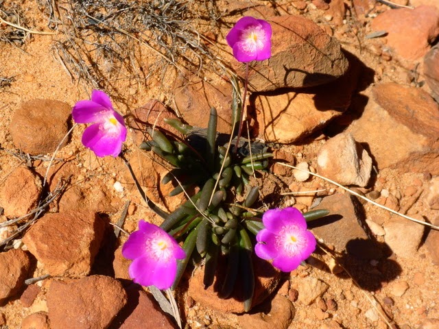
Mulla Mulla  (just like my placemat)
There were plenty of good campspots around the dam, but it was too early to stop for the day, so we continued on to Kookynie, a “living” ghost town.   After lunch here, it was 50 k’s of good dirt road to the highway to Laverton.    Along this section of road we passed Lake Raeside, and were pleasantly surprised by the amount of water and birdlife.    I also spied my first desert pea of the trip, and it was such a vivid colour.     Just 100 k’s then to Laverton, past nickel and cobalt mines.

Lake Raeside
 

Such delicate flowers in a barren landscape
Friday morning dawned clear and cold for the start of our adventure on the Great Central Road, also known as The Outback Way, Australia’s Longest Shortcut – the route from Laverton to Winton.   Our first day’s travel was 315 k’s which included some very challenging corrugations, and quite good dirt.   We travelled at speeds between 10 and 80 kph.     Our overnight stop was the Tjukayirla Roadhouse, which provided a very good campground and excellent showers/toilets, especially considering the remoteness of the place.  

Start of The Great Central Road
Lunch stop - Day 1

Tjukayirla Roadhouse - fuel in cages
Sunset behind, moon in front
Road conditions to Warburton on Saturday were quite good, with about 30 k’s of bitumen, which was a nice change.    We stayed at the roadhouse overnight, keeping a keen eye on the dark clouds coming in late in the afternoon.   After an early start on Sunday morning, the driver was becoming very concerned about the possibility of rain.   We made good time to Warakurna for fuel, hot coffee and chips, so decided to keep going.   
Just a few corrugations!!!!!
Lots of footprints, but only 3 camels on the road

Avenue of desert oaks
.......... and the worst section of road


The road was in good condition until the WA/NT border where it quickly deteriorated, for many kilometres past Docker River.    It had started to rain, and the idea of spending a night beside the road was not a favoured option.    A decent downpour and we could be stuck.   Luckily we met the grader driver working his way along the road, and he said we just had about 10 more k’s of bad road, then it would be good right to Yulara.    We were very pleased to come across the newly graded road as it had begun to rain quite heavily and was getting dark.

We reached the bitumen leading in to Yulara around 7 pm, and made our way to the campground.  We thought we knew our way around the camp fairly well, having stayed here twice before, but this time we were placed in the overflow area, as they were allegedly full.    It was very stressful trying to find our way up to the back of the property, through very narrow “streets” in an area we didn’t know existed.  

On Monday morning when we went to check out our allotted powered site, it was still occupied, so we stayed in the paddock – much less crowded (and $10 instead of $48 per night).   I had lost track of which states were on school holidays, but it could well have been everyone by the number of vans, tents, and children at Yulara.    The morning was very cold and overcast, but during the day the clouds cleared somewhat, so I took advantage of the lookout in the park to view Uluru near sunset.   I am glad we have seen The Rock at its best, and we did not have to stay here any longer than necessary.

Lots of room in the paddock
Uluru from the campground lookout
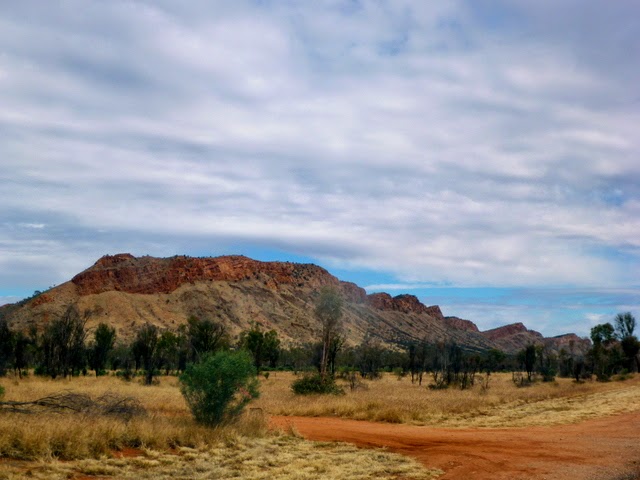
The Olgas in profile